Please see below a list of the questions that we have received on the project, with answers.
If you have any questions about the project, please feel free to contact us using the contact details at the bottom of this page.
- Has planning permission been granted for the project?
No, planning permission has not been granted for the project.
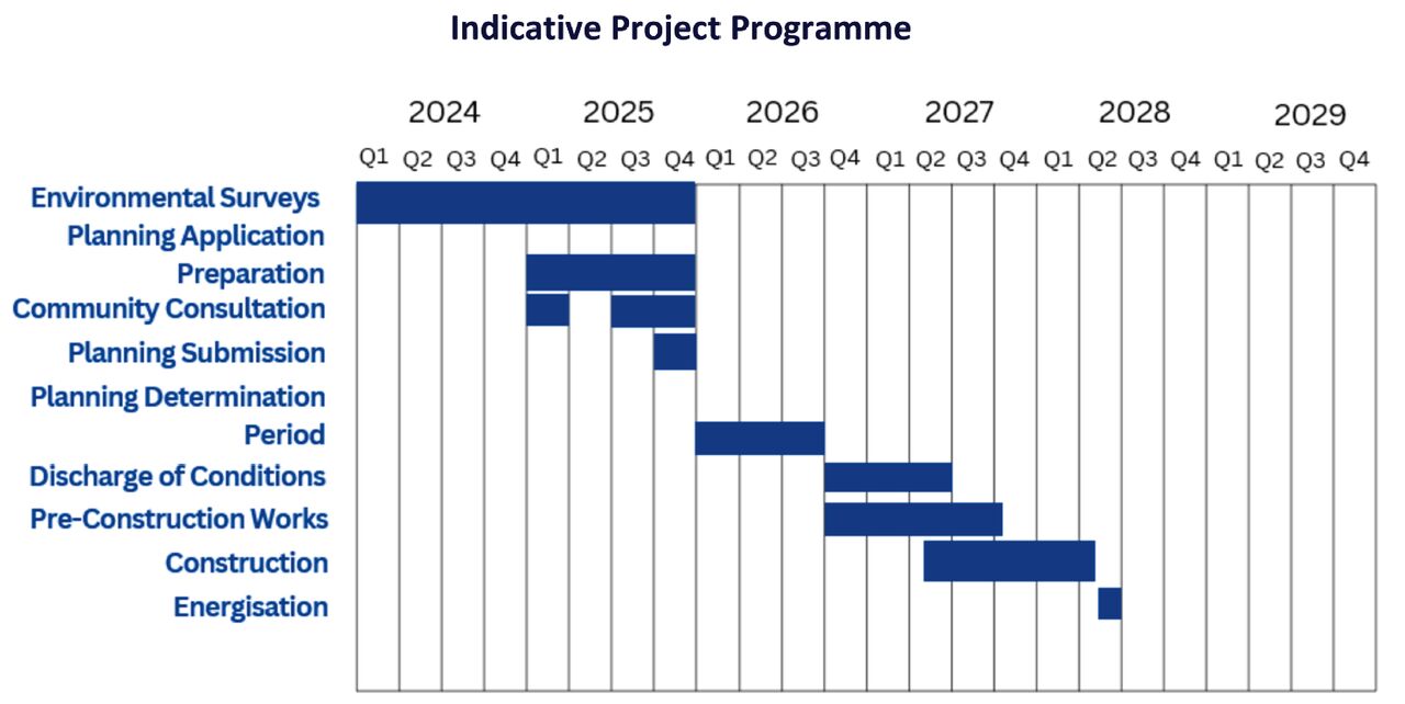
The planning application is planned to be submitted in December 2025. Following this there will be a 36-week determination period within which a decision should be made. There is a possibility that the determination period could be suspended, which could result in the decision being delayed. - Will the planning documents be made public?
Draft planning documents are available on this website on the 'Draft Planning Application Documents' page.
The finalised documents that form part of the planning application submission will be published on the Welsh Government's planning casework portal.
The planning application is planned to be submitted in December 2025. - Has the Community Council been provided with information on the project?
Yes, Freystrop Community Council are being consulted on the project and their comments will be considered during the development of the planning application. - Why has this site been chosen?
The site has a number of characteristics that make it suitable for a solar and battery storage project. It includes a viable point of connection to the local electricity network, making it possible to export renewable energy efficiently to where it is needed. The majority of the land is gently sloping, has good solar exposure, and is positioned in a landscape that allows for effective screening and integration of the development within its surroundings.
The site also offers opportunities for meaningful ecological enhancement through new planting, habitat creation, and careful management of existing field boundaries. In addition, the proposal aligns with local and national planning policy objectives to increase renewable energy generation and support the transition to net zero. - When will the project start?
If the project receives planning consent in September 2026, construction could be expected to start around Q2 2027. An indicative project programme is provided at the bottom of this page. - What will happen to the site after the 40 year operational life?
After 40 years the infrastructure will be removed and the site will be restored to its original condition. - Does the proposed project include panels being installed on Middle Hill Farm as well as White House Farm?
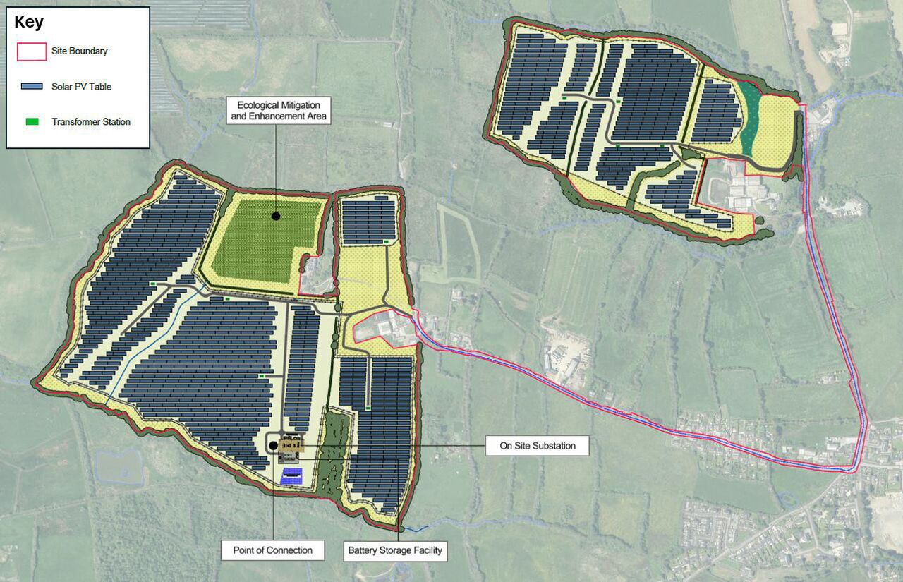
Yes, the project includes solar panels on both White House Farm and Middle Hill Farm. An indicative site plan is provided below. - How will the project benefit the community?
The broader benefits of the scheme are detailed on the Benefits page of the project website. A community benefit fund would also be created - exact details on how funding would be distributed is to be confirmed, and we welcome your input on this (contact details are provided at the bottom of this page). - Will the project impact the wildlife in the area?
A number of environmental surveys have been undertaken at the site to allow appropriate measures to be put in place to protect the local environment and its ecology during the project lifetime. The project is expected to introduce significant biodiversity improvements to the site through the creation of wildlife-friendly habitats. - Will the project impact the wildlife in the area?
All biodiversity measures proposed as part of the project will be secured through the planning process. This means that once permission is granted, the project must deliver the agreed environmental commitments set out in the approved plans and reports.
During construction and operation, ecological specialists will monitor progress to ensure that habitat creation, planting, and management are carried out as intended. Regular reporting and maintenance plans help to make sure these enhancements are maintained over the lifetime of the project, so that genuine and lasting biodiversity benefits are achieved. - How has the land surrounding the proposed development been considered?
The surrounding land and its relationship to the proposed development has been carefully assessed as part of the design process. Detailed environmental, landscape, and ecological studies have been carried out to understand local habitats, views, and land uses.
The layout of the project has been designed to make use of existing field boundaries, hedgerows, and natural screening, helping the development fit sensitively into the landscape. Additional planting and habitat creation are proposed on the site to further reduce visibility and enhance biodiversity.
We have also considered nearby homes, public rights of way, and local heritage and landscape features to ensure the project minimises impacts on nearby residents and the wider area. - Will the residents of Moorland Road receive compensation for the disruption whilst the site at White House Farm is being built?
Every effort will be made to minimise disruption to Moorland Road during the construction period. Any method of work will have to be independently approved by the local highway authority. It is not usual practice to pay compensation in these circumstances. - Will compensation be provided for the devaluation of homes?
There is no mechanism within the planning system to compensate homeowners for any perceived change in property values. Planning decisions are based on whether a project is appropriate in planning and environmental terms. The design of the project includes careful site layout, landscape screening, and ecological enhancements to minimise local impacts and help the scheme fit sensitively into its surroundings. - How will disruption to businesses on Moorland Road be managed during construction? Will compensation be provided?
We understand that local businesses rely on Moorland Road for deliveries, customers, and staff. The construction team will prepare a detailed Construction Traffic Management Plan (CTMP) to manage HGV movements and minimise disruption as much as possible.
This plan will include measures such as scheduling deliveries outside peak traffic hours and carrying out loading and unloading activities within designated construction compounds off the public highway. While there is no mechanism to provide compensation for short-term disruption, our priority is to maintain access and minimise impact so that local businesses can continue to operate safely throughout the construction period. - Will the project result in a discount on energy bills for those living in the vicinity of the project?
The project will not directly reduce electricity bills for local residents, as energy prices are set nationally by suppliers rather than by individual generation projects. However, by increasing the amount of locally produced renewable energy, the project does contribute to a more resilient and sustainable energy system. In the long term, adding more low-cost solar generation to the grid helps to reduce reliance on imported fossil fuels and can help to stabilise or lower wholesale electricity prices for consumers.
In addition, we are exploring opportunities for local benefit initiatives such as community funds, educational programmes, and local partnerships, to ensure that the surrounding area shares in the wider benefits of the project. - How much traffic is the development expected to create?
The majority of HGV traffic is anticipated to occur in the first 8 weeks of the construction phase. During this period, a total number of 6-7 HGV deliveries are anticipated per day to the proposed development (6-7 trips to the development, and 6-7 trips away from the development). These delivery figures are the combined total for both the White House Farm and Middle Hill Farm land parcels, and the number of deliveries to each individual land parcel is therefore expected to be less.
After the initial 8 weeks, a total number of 3 HGV deliveries are anticipated per day to the proposed development from weeks 9-28. No further HGV deliveries are anticipated after week 28.
In addition to the HGV movements, staff trips to site will create some additional traffic. The increase is expected to be largest during weeks 9-28, when approximately 40-45 trips to the development and 40-45 trips away from development are anticipated per day during peak activities. As for the HGV delivery figures above, these figures are the combined total for both the White House Farm and Middle Hill Farm land parcels, and the number of trips to each individual land parcel is therefore expected to be less. There may be the option to reduce the number of staff trips to and from the White House Farm parcel through the use of a minibus service.
Further information on the traffic anticipated to be generated by the development is presented in the draft Transport Statement on the 'Draft Planning Application Documents' page on the project website. - How will construction traffic and road access be managed during the works?
The detailed traffic management measures required to manage construction vehicle movements will be finalised by the appointed contractor. These measures will be developed in consultation with the Local Highway Authority and will require the appropriate licences and agreements, which are controlled outside the planning application process.
A draft Outline Construction Traffic Management Plan is available on the 'Draft Planning Application Documents' page on the project website.
The Outline Construction Traffic Management Plan sets out the typical measures expected to be implemented, including temporary passing bays, timed delivery slots, wheel cleaning facilities, and driver instructions based on British Horse Society guidance.
For the cable installation between White House Farm and Middle Hill Farm the traffic management measures would be determined by the appointed contractor and a suitably qualified traffic management specialist, and agreed with the Local Highway Authority through the Section 50 process. It is anticipated that a one-way working system, controlled by traffic signals or ‘stop & go’ signs, would be implemented where possible, however the 610m long section of Moorland Road leading to White House Farm is likely to be too narrow to accommodate this. For this section, potential approaches that could be explored include:- Rolling short closures, with controlled resident access under banksman escort;
- Time-controlled closures with advance notification to residents, ensuring defined access windows;
- Temporary verge strengthening (where possible) to maximise residual carriageway width – although this may be constrained along parts of the 610m long section due to grass banks on either side;
- Trenchless installation in the narrowest sections to reduce open-cut working time in the carriageway; and
- Night-time or off-peak working, to limit daytime disruption.
- What times will vehicles access the site?
The exact timetable for construction vehicle access will be finalised after the planning process and once a contractor has been appointed. The agreed hours will need to comply with the necessary licences and highway approvals, which are managed separately from the planning application. The application currently proposes construction works to take place between 8am and 6pm Monday to Friday and between 8am and 1:30pm on Saturdays. - How will pedestrians and horse riders along Moorland Road be accommodated?
A strategy for ensuring the safe movement of construction vehicles alongside pedestrians, cyclists, and horse riders on Moorland Road is set out in the Outline Construction Traffic Management Plan – a draft copy is available on the 'Draft Planning Application Documents' page on the project website. This includes an equestrian-awareness training checklist for all drivers (in accordance with British Horse Society guidance), daily site briefings and inductions, and appropriate signage and communication measures.
These measures provide a framework for how construction traffic will be safely managed. The detailed arrangements will be finalised by the appointed contractor, working in collaboration with the Local Highway Authority through the separate consenting and permitting process, which ensures that the final scheme meets all safety and operational requirements. - Will access to the bridleways to the west of Moorland Road be affected?
At this stage, we do not anticipate that access to adjacent bridleways will need to be closed. The Outline Construction Traffic Management Plan sets out the principles that will be followed to ensure safe use of the bridleways during construction - a draft copy is available on the 'Draft Planning Application Documents' page on the project website. The detailed arrangements, such as the exact management measures, signage, and any temporary localised controls, will be finalised by the appointed contractor in consultation with the Local Highway Authority and the Rights of Way team through the separate consenting process. This ensures that all public access is managed safely and appropriately while allowing construction to proceed efficiently. - How will risks around the Moorland Road/Targate Road Junction be addressed?
A review of this junction will be undertaken as part of the planning application, which will include an analysis of the local junction raised in the question. This assessment will consider current traffic conditions, recorded accident data and the additional construction traffic expected for the project. Where any potential risks are identified, appropriate mitigation measures will be proposed within the Transport Statement and the Outline Construction Traffic Management Plan (draft copies of these documents are available on the 'Draft Planning Application Documents' page). These may include measures such as clear signage, controlled delivery times, driver briefings, and on-site traffic management to ensure safe movements at the junction.
The final, detailed arrangements will be developed by the appointed contractor and agreed with the Local Highway Authority through the approval of the Construction Traffic Management Plan. This ensures that any risks at the junction are properly managed and that construction traffic operates safely and responsibly. - How long will it take to install the cable between White House Farm and Middle Hill Farm?
The project would include the installation of a cable along Moorland Road, a short section of Targate Road, and along a section of Pembroke Road.
The cable installation will very likely be undertaken in sections. Experience from other projects suggests that it may be possible to lay a 50-100m length of cable per day. The cable installation along Moorland Road and Targate Road could therefore be estimated to take 10-20 days, and the cable installation along Pembroke Road could be estimated to take 7-15 days. - If Moorland Road is damaged by the construction traffic for the project, will the road be repaired?
A conditions survey will be completed prior to works commencing and agreed with the local highway authority. Should any damage occur during the construction period the road will have to be reinstated to the satisfaction of the local highway authority with all costs being met by the contractor. - Will you pay for structural surveys for properties in the vicinity of the access roads in case the construction traffic causes damage to the foundations?
We understand that residents may be concerned about potential vibration from construction traffic, particularly given the area’s history of mining activity. The level of vibration from vehicles on public roads is very low and is not of a type or magnitude that would be expected to cause structural damage to buildings, even where old mining works may exist.
For this reason, structural surveys of nearby homes are not typically required for developments of this nature. However, the Construction Traffic Management Plan will include measures to minimise disturbance to residents. - How will you make sure underground utilities are not affected by HGV movements?
Public roads are built to safely accommodate heavy vehicles, and the utilities buried beneath them - such as water and gas mains - are designed and installed to withstand those normal traffic loads. For that reason, construction traffic using existing roads is not expected to pose any additional risk to underground infrastructure.
Where works take place on private land, utility records will be checked in advance and, if necessary, protective measures will be agreed with the relevant service providers to ensure any buried infrastructure is safeguarded. - Have the utilities in the road been considered in the design?
Yes. As part of the project planning, existing utilities such as water, gas, electricity, and communications along the road have been reviewed. Construction activities will be planned to avoid any risk to these services. Public roads are designed to safely accommodate heavy vehicles, and the utilities beneath them are installed to withstand normal traffic loads. For work on private land, additional checks and protective measures will be put in place as needed. - Could access have been arranged through the existing solar farm to the northwest of White House Farm to minimise additional traffic on Moorland Road?
The option of accessing the White House Farm land parcel through the existing solar farm to the northwest of White House Farm has not been pursued. The land between the two sites is separated by dense vegetation and woodland, which provides valuable habitat and natural screening. Creating a new access track through this area would require significant clearance, likely causing avoidable ecological disturbance.
We recognise that traffic on Moorland Road is a key concern for residents. The proposed access route is still being assessed through detailed transport studies, which will consider safety, visibility, and the practical management of construction traffic. Feedback from the local community will help shape these plans before they are finalised. - Where can I go to visit an existing battery storage site?
The UK Government's Renewable Energy Planning Database includes data which shows the status of renewable energy and battery storage projects in the UK. It is updated quarterly, and allows projects at various stages of development to be viewed on a map - link here: https://www.gov.uk/government/publications/renewable-energy-planning-database-monthly-extract. This can be used to identify operational battery storage projects near you.
Please note that the technology to be used as part of the proposed development is very likely to be newer than the technology used in existing battery developments, and the existing developments may therefore not be representative of what is proposed.